 sagi
sagiOn 21 May 2011, I found the sign before I found the monument.
It stood near Sanjak, in Purig, on the western side of Ladakh, where the road had already taught me not to trust the clean lines of a map. I was travelling by bicycle. The previous summer’s flood was still present in the road itself: damaged stretches, broken surfaces, places where travel had become slower and more physical. I carried a letter written by another traveller who had passed through before me. In it was a phrase I had copied into my own search: PROTECTED MONUMENTS SKINBRISSA.
The sign seemed to settle the matter. I had reached the place.

Then I spent about two hours looking and could not confidently find what I had come to see.
There was something almost comic in the arrangement. An official board told me that a protected monument existed here. My own eyes could not produce it. I moved among rock and slope, looking for carved surfaces, trying to turn the information in the letter and the authority of the sign into something visible. A single mark could make me stop. A natural line in stone could become suspicious. Then it would become only stone again.
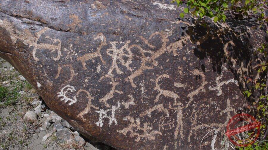
Years later, an Archaeological Survey of India review gave Skinbrisa a precision that my day there did not have. The survey, published in 2004, recorded a site near Sanjak and described one boulder carrying at least forty-seven figures of ibex, along with hunting and battle scenes. Someone trained to survey rock art had stood in this landscape before I arrived and had known what to record. The place was not waiting for me to discover it.
In the notebook, effort naturally occupied the foreground. I crossed passes, broke things, asked questions, searched longer. Read years later, that sequence can make motion feel like entitlement, as if enough difficulty should eventually oblige the landscape to reveal itself.
In 2011, I was still capable of writing that way.
The rocks were under no such obligation.
I moved on toward Pussa, also written Fussa in some accounts. There, later the same day, the problem reversed itself. I recorded not scarcity but abundance: many boulders carrying rock art across a broad area. What I had strained to find near Skinbrisa seemed suddenly to multiply.

At the time, I treated that contrast as part of the adventure. One place withheld itself; another opened. I knew little enough to think the important difference was probably my own luck.
Now I am more interested in the failure.
Before I left the area that day, water offered a different kind of map.
Near Pussa, I recorded a spring called Fussa Zin. I remember the water as unexpectedly sweet. That description belongs to the senses, not to chemistry; I did not test it, and I have no reason to turn a traveller’s taste into a property of the spring. Still, the memory matters because it interrupts the archaeological appetite of the day. I had gone looking for marks made by people long before me, but thirst made the landscape immediate. A spring did not need to be ancient to matter.

Now the contrast matters for another reason. Archaeology trains attention toward traces that survive. Travel is full of things that do not: the temperature of water in the mouth, dust on skin, a bicycle leaning against a wall, the exact angle at which afternoon light makes a shallow groove visible. A carved line may last centuries while the conditions under which one person noticed it vanish before evening.
It is one reason I distrust the phrase “timeless landscape.” Nothing I encountered was outside time. The road was carrying flood damage from the previous year. Water emerged from rock and disappeared downslope. Villages were working through ordinary days. The carved boulders were old, but the act of seeing them was brief.
At Pussa, abundance did not make the carvings easier to understand. It simply changed the scale of the question. One carved boulder can be treated as an object. Many carved boulders across a wide area begin to implicate movement: why these surfaces, along which routes, seen by whom, added to when? The landscape stops behaving like a cabinet of specimens.
My photographs from those days often did the opposite. The closer I moved to a motif, the more context I removed. This was sensible if the goal was to make the line visible. It was less useful if the later question became where exactly the boulder sat in relation to water, road or slope.
I did not know I was making that trade.
To look at rock art is to confront a peculiar fact about vision. A carving can remain on a surface for centuries and still be invisible to the person standing beside it. Light matters. Height matters. The direction of the cut matters. Weathering matters. Expectation matters. Most of all, knowledge matters. A person who knows which wall to scan, which boulder to circle, which valley side to follow is not merely seeing more sharply. He or she is inhabiting a different map.
My first map was mostly empty.
Two days later, at Darchay, the stones moved above my normal line of sight.
The record I made that day describes carvings beginning roughly three metres above the ground and continuing higher on the rock face. One of the teachers brought a short wooden ladder. I climbed, then used a tree to reach a better angle with the camera. The branch moved beneath me. Below, the teachers laughed.

What survives most strongly in the old entry is not a theory about the carvings. It is the awkward geometry of the scene: rock face, ladder, tree, camera, bodies below, my own body trying to get high enough to make the marks legible inside a rectangular frame.
The height changed the problem.

I had been thinking of petroglyphs as objects on rocks, as though “rock” described a conveniently available surface. But a cliff is not a museum wall. A boulder field is not arranged at eye level. A mark that was accessible to the person who made it may become difficult to reach because the ground below has shifted, eroded or accumulated debris. Or the placement may have been high from the beginning. Without evidence, I cannot know which explanation belongs to Darchay. What I can say is that the camera forced me to notice a simple fact: the carvings occupied the landscape in three dimensions, not as illustrations laid flat across it.
Even the word I had been using needed more care.
“Rock art” is a broad shelter of a term. Many of the marks I was seeking were petroglyphs: images or signs made by cutting, pecking, incising or otherwise removing part of a rock surface. But not every mark in Purig should be assigned the same age, maker or meaning simply because it appears on stone. Dieter Schuh would later make this caution explicit in a large study of Purig’s antiquities: not all the drawings grouped under the convenient heading of prehistoric petroglyphs necessarily belong to prehistoric periods.
That warning seems obvious once stated. In the field, it is easy to forget.
Age has a visual seduction. Dark stone, pale cuts, animals with long horns, riders, signs one cannot read: the mind wants to push all of it backward into a single remote past. The landscape encourages the mistake because the mountains themselves seem old enough to make every human mark look temporary.
But rock surfaces are archives with additions. Different people can return to the same stone. A route can remain useful across political and religious change. An ibex cut into a boulder and an inscription beside it need not belong to one moment simply because they share a surface.
In 2011, I did not yet know how much discipline was required to leave a mark uninterpreted.
I photographed because photography felt like the safest form of keeping. The camera could preserve the pattern even when I did not understand it. But a photograph has its own confidence. It cuts away the slope below, the road beyond, the person who indicated where to look, the distance from the nearest house, the weather, the angle of the sun. It makes the carved surface appear self-sufficient.
The experience was the opposite.
The ladder at Darchay taught me what photographs conceal about scale.
In a photograph, a petroglyph can fill the screen. The viewer may have no sense whether it is the size of a hand or whether the whole panel lies several metres above the ground. The image becomes portable and, in becoming portable, loses resistance. On the rock face, resistance was the point. I had to change position. The camera had to be carried upward. My balance mattered.
That physical inconvenience kept the marks from becoming pure information.
A catalogue can group motifs by type. A database can attach coordinates. Both are indispensable forms of knowledge. But the field also asks primitive questions: Can I reach that surface? Is the mark visible in this light? Is the stone stable underfoot? Am I looking at a cut made by a person or at a fracture made by weather? The body does not answer archaeological questions, but it tells you when abstraction has outrun the place.
I had arrived in Purig with the habits of a traveller taking photographs. I began, slowly, to acquire the habits of someone documenting evidence, though I did not yet have the method to do it well.
That difference is visible in what I failed to record.
I rarely made systematic wide shots before moving close. I did not establish a scale beside every motif. I did not write a coordinate for every boulder. I did not number panels in a way another person could reproduce. I photographed what attracted my eye.
This is a perfectly ordinary way to make travel photographs.
It is a frustrating way to build a future comparison.
Fifteen years later, when environmental change becomes part of the question, the missing context grows louder. If a channel has shifted, a slope has failed or a road has been widened, a beautiful close photograph of a carving may tell you almost nothing about the change around it.
The picture preserves the mark and loses the ground.
That tradeoff became one of the hidden subjects of the archive.
Again and again, the stone became visible only in relation to everything around it.
The following day, 24 May, I stopped at a tea shop in Shakar.
I had tea and Kashmiri bread. The bill was twenty rupees. Dust had worked its way into one of my ears. The owner advised me not to take the bicycle over the pass.

I took it anyway.
The decision looked less impressive a few hours later.
Wind pressed across the route toward Panley La. The sun was strong. I pushed more than I rode. The rear wheel took the strain until the rim broke and the inner tube burst.
A bicycle that rolls easily disappears beneath the rider. Weight becomes momentum. A bicycle with a failed rear wheel does the opposite. Every kilogram returns. The machine has to be lifted, dragged, balanced, leaned against something, moved again.
The tea-shop owner’s advice came back to me with irritating clarity.
The wind did not make the route dramatic so much as repetitive. Push, stop, adjust the bicycle, push again. With the rear wheel damaged, every rough patch had to be negotiated separately. Distance stopped behaving like a number and became a succession of surfaces under my hands and feet.
I had ignored information from someone who knew the route because I wanted to keep my original plan intact.
That pattern was becoming familiar.
In the first days of the search, I kept assuming that determination could compensate for imprecision. If a place was difficult to find, walk farther. If the first direction failed, ask again. If the slope looked wrong, climb another one. The bicycle gave that instinct a physical form: keep moving until movement itself becomes evidence of seriousness.
The broken rim made movement slower without making the landscape clearer.
By then, the names in my notebook had begun to behave differently on the ground.
Skinbrisa.
Pussa, or Fussa.
Darchay.
Yokma Kharbu.
Written down, they looked like destinations. Each could fit neatly on one line. In the valley they were attached to roads, drainages, cultivated ground, slopes, older localities and the practical language of people giving directions. A spelling that was adequate for a travel diary did not necessarily tell me where to put my feet.
That was one of the quiet difficulties of the trip. The map in my head was assembled from fragments: an earlier traveller’s letter, a sign, what I had just been told, what I thought a place-name referred to, what the road seemed to be doing. Each fragment could be accurate and still fail to produce a useful route when I combined it badly.
The landscape did not need to be remote to defeat me.
It only needed to be more specific than my information.
At Shakar, the specificity had been simple: leave the bicycle.
I had preferred the harder answer.
There is a vanity in that preference that I recognize more easily now. Travel can make unnecessary difficulty look like authenticity. A pass crossed with a broken bicycle feels more narratable than advice followed at a tea shop.
But the tea-shop owner had understood the route.
I had understood my story about the route.
The difference was sitting in the rear wheel.
I continued with the damaged bicycle because there was little else to do. The day narrowed into practical decisions: how to carry the load, where to place the rear of the frame, how far the next section might be, whether the surface would allow the bicycle to be pushed without causing more damage.
The failure changed the scale of attention.
When travel is going well, distance can become abstract. A road is a number of kilometres. A pass is a point to be crossed. When equipment fails, the next hundred metres returns to the body.
The same thing was happening in my search for rock art.
I had begun with names and general locations.
The carvings kept forcing me back toward metres, angles, surfaces.
A sign could put me near a monument and still leave me unable to identify it.
A marked rock face could place the carvings above where I had been looking.
A valley full of boulders could contain far more than one point on a map suggested.
The broken bicycle belongs beside those failures because it stripped away the romance of access.
Reaching a village did not mean understanding the ground around it.
Crossing a pass did not make the next direction correct.
Physical effort did not confer knowledge.
The tea shop, in retrospect, is one of the clearest scenes in the old record precisely because nothing mysterious happened there. A man who knew the route gave practical advice. A traveller ignored it.
The mountain did not punish me.
The wheel broke.
That was enough.
By the time I reached the Yokma Kharbu part of the journey, I was moving more slowly, carrying a damaged machine and a notebook full of names that had proved less stable than I wanted them to be.
The route had become heavier.
My confidence had become lighter.
On the morning of 25 May, I woke to birds and the sound of yak.
I washed my head and face with cold groundwater. The cold was immediate enough that it erased whatever sleep remained. I packed the tent and sleeping bag and tied them to the damaged bicycle. The rear wheel was still useless as a wheel, but the frame could carry weight. I had entered Yokma Kharbu looking for old marks in stone and begun the day with the ordinary problem of how to move a broken bicycle.

That detail has become more valuable with time.
Without it, the day can be made to look inevitable: morning, valley, carvings, revelation. The damaged wheel keeps the sequence awkward. Nothing had arranged itself for the story.
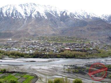
My notes then move downstream along Yokma Kharbu Nala. Houses and cultivated land occupy the first part of the route. Farther on, the agriculture ends and the valley narrows. Dark boulders become more numerous.
The change is gradual enough in the old entry that I did not mark a dramatic boundary. Fields simply stop. Rock takes over more of the ground.
Then the carved surfaces begin to multiply.

In my 2011 notes I estimated that the rock-art area continued for about a kilometre. It was not a measured transect. I had no survey equipment, no panel numbers, no systematic start and end points. The number belongs to the scale of what I thought I was seeing: not one famous boulder, not a panel beside a road, but an extended landscape in which I kept encountering marks.
The camera took over the pace.
I stopped, framed, pressed the shutter, moved, stopped again.

In the old entry, the repeated camera sound becomes one of the noises of the valley. The detail is almost absurd beside the age I was imagining for the carvings. The stones had no need to hurry. I did.
I also ate apricot kernels that morning. I remember them as mild and slightly almond-like. At one point I put too many in my mouth and coughed.
The cough has survived in memory beside the carvings.
That seems right.
A human body does not become archaeological simply because it enters an archaeological landscape. It gets thirsty. It misjudges food. It carries broken equipment. It becomes impatient. The camera strap pulls at the neck. Sun and wind continue whether a petroglyph is in the frame or not.
The old photographs often remove all of this.
A close image of a carving can make the rock look detached from gravity. There may be no clue whether the surface was beside a path, above a channel, part of a freestanding boulder or connected to a larger face. The camera can make a difficult object look conveniently available.
On the ground, availability was never guaranteed.
The same valley that offered many visible carvings also made my ignorance measurable. I knew the route I had walked. I did not know the full extent of the marked landscape. One local statement recorded in my notes said that still more Skinbrisa existed on surrounding mountain tops. I had no way to verify that claim then, and I still cannot turn it into a mapped fact. But it changed the scale in one important way: the visible route under my feet was not necessarily the boundary of what local people understood to be there.
That difference had already appeared elsewhere in smaller forms.
An official sign near Sanjak had not been enough to make the expected carvings visible to me. At Darchay, the height of the marked surface had changed the act of looking. At Pussa, abundance had surprised me because I had arrived with no reliable sense of scale.
Yokma Kharbu brought those failures together.
I had been treating the search as a test of persistence. If I walked farther, climbed longer, asked more questions, eventually the landscape would yield.
But persistence is only useful when directed.
A person can spend two hours looking in the wrong way.
A person can stand under a marked rock face and keep his eyes too low.
A person can cross a pass with a bicycle he was advised not to take and arrive no better informed for the effort.
The carvings did not reward endurance. They exposed its limits.
Here the language I used at the time begins to trouble me.
Travel writing likes the verb “discover.” It gives motion a prize. You go somewhere difficult, see something unfamiliar, and the sentence quietly makes your arrival the important event.
In its smallest sense, I did discover things for myself in Purig. I had not seen those boulders before. Surprise was real. Excitement was real.
But the places were not waiting for me.
The carvings themselves were evidence of earlier human attention. Local residents knew names, paths and locations that I did not. Archaeological work at Skinbrisa predated my trip. My photographs belonged to a much longer chain of people seeing, using, naming, recording and interpreting the same ground.
Once I remove the heroic version, the day becomes better.
I no longer have to pretend that the value of Yokma Kharbu lies in being difficult for me to reach. The broken wheel becomes what it was: a broken wheel. The valley becomes less like a prize and more like a place whose scale exceeded my preparation.
I can pay attention to smaller things.
The cultivated land ending.
The first dark boulders.
The rhythm of stopping for the camera.
The cough after too many apricot kernels.
The fact that one frame after another removed the wider valley in order to preserve a shallow cut in stone.
Those details carry their own tension. I was trying to keep what I saw by narrowing my view.
At the time, narrowing worked.
The carvings became clearer in the photographs.
Only years later would I understand what had been lost at the edges.
Four years passed.
In 2015, the International Institute for Tibetan and Buddhist Studies published Burgen und Altertümer von Purig, a 324-page large-format volume by Dieter Schuh, prepared with the collaboration of Ajaz Hussain Munshi, Temba Schuh, Mohammed Fayaz and me.
My name in that list still looks slightly improbable.
The book ranged across castles, antiquities, historical places and material remains in Purig. In its contents were sections on the petroglyphs of Yokma Kharbu, Pussa and Darchay. I knew those names first as destinations written into a travelling day: a place to reach before dark, a direction asked in a village, a valley where the camera kept stopping me. On the page they sat differently. They belonged to a larger record.
A table of contents is one of the driest ways a place can survive on paper. It reduces valleys to headings and page numbers. Yet that reduction also removes the traveller’s sequence. Pussa is no longer important because I happened to reach it after Skinbrisa. Darchay does not matter because I climbed with a camera. Yokma Kharbu is not the climax of a difficult day. The names sit beside one another because they belong to a field of evidence larger than my itinerary. That rearrangement was useful. It broke the private chronology in which every place had been organised around my arrival.
The change was not that the book transformed my journey into archaeology. It did not. I was not an archaeologist, and the old entries did not become field reports simply because my name later appeared in a scholarly volume. What changed was the pressure placed on my earlier certainty.
Schuh warned that not every rock drawing gathered under the heading of prehistoric petroglyphs should automatically be assumed to be prehistoric. The caution is small enough to pass quickly in a large book, but it altered the way I looked back at my own photographs.
In 2011, age had seemed to arrive visually. Dark stone, pale cuts, long-horned animals, riders, signs I could not read: the eye wanted to push everything backward together. A figure looked ancient, therefore I let it carry an ancient story. A group of marks invited a procession, a hunt, a belief, a people.
The photographs themselves said less.
They showed lines on particular surfaces.
They showed what the light allowed the camera to catch.
They did not tell me who had cut the lines or when.
Once I began rereading my 2011 notes beside the later scholarship, I could see how often a sentence had crossed that distance too quickly. The photograph might be careful while the caption was impatient. The stone remained where it was; the language rushed ahead.
At Yokma Kharbu, this mattered especially because scale had overwhelmed me. I had moved through an extended field of carved boulders and estimated, roughly, that the rock art continued for about a kilometre. I had been looking at quantity. The book forced another kind of attention: not how many marks I had seen, but how little a large number of marks allowed me to conclude by itself.
One surface could contain additions from different moments. A route could be used across generations. A later inscription could occupy a stone already marked. The fact that images shared a valley did not make them one event.
The mountains had encouraged a false simplicity. Their mass made human marks seem brief; their age made every carved line seem equally old. But the human record on stone is not arranged for a visitor’s convenience.
I returned to the photographs.
The close views were still the most seductive. A carved animal filled the frame. The rock became almost flat. There was no road, no field, no person, no nala, no sense of how far I had walked to reach it. The image looked complete because everything outside the rectangle had been removed.
The wider photographs were messier and, years later, sometimes more useful. They retained neighbouring boulders, slope, pieces of sky, fragments of ground. What had once seemed like visual clutter began to look like location.
I had not photographed with that future in mind.
In my 2011 notes, Yokma Kharbu was still a day with a beginning and an end. I woke, washed, packed, walked, photographed, moved on. In the 2015 book, the same place sat inside a longer historical landscape. Neither form cancelled the other. They simply asked different things of the same ground.
One preserved sequence.
The other demanded classification and restraint.
Between them, my old certainty became harder to maintain.
That was useful.
The stones did not need me to make them mysterious. They needed me to stop pretending that mystery was the same as knowledge.
The road I bicycled in 2011 had already been rearranged by water.
The catastrophic Ladakh flood of August 2010 had come less than a year before my trip. A Government of India situation report dated 11 August recorded six affected villages in Chiktan Block. My own entries from the following spring still found the event in the landscape. I wrote of extensive damage along the Shakar-Chiktan corridor and named Shakar, Chiktan, Yokma Kharbu and Sanjak among places affected in 2010.

Near Skinbrisa, after two hours of unsuccessful searching, I wrote that I thought the previous year’s flood might be one reason the expected carvings were difficult to find.
I believed that in 2011.
I cannot prove it now.
The road, however, required no theory. It had broken surfaces. Travel through the corridor had changed. The flood had entered the journey before I knew that, fifteen years later, I would return to the photographs and ask what else water might have changed.
For me, 2010 became a sharp date because I saw damage soon afterward. The sediments of Ladakh tell a less convenient story. Research published in 2016 found evidence of a long history of flash floods and debris flows caused by intense storms. The same study concluded that such events appeared to have increased in frequency during the decade leading up to its publication.
Both scales matter.
A traveller remembers rupture.
A landscape remembers repetition.
The years after my trip did not make the question disappear. Official records from Shakar-Chiktan describe new episodes. Flash floods and mudslides affected villages, roads and agricultural land in 2021. In 2022, after a cloudburst, the Yokma Kharboo-Shakar road was blocked at gorges, agricultural land lay under debris, and one nallah was reported completely covered by boulders. In 2025, authorities again recorded flood damage in and around Shakar Chiktan: roads, irrigation, water systems, fields, public buildings and households.
These records are practical documents. They are concerned with what must be reopened, cleared, repaired, restored.
A road declares its damage.
A house does too.
A carved boulder may not.
It can move and leave no complaint. It can be buried and remain intact but unseen. Debris can change the route by which a panel is reached. A road cut can remove part of a slope. Erosion can soften a shallow line without producing a single moment that anyone records as loss.
Recent climate research adds another scale. A 2026 analysis of Ladakh found a clear regional warming signal and increasing climate variability, including more frequent cloudbursts and flash floods, while also noting limits in precipitation records and the measurement of extreme events. Separate government-supported work on Ladakh’s geoheritage identifies petroglyphs and other geosites as vulnerable to changing climatic conditions, mass wasting, erosion and development.
Those findings sharpen the question around the stones, but they do not answer the most tempting version of it.
I cannot say that anthropogenic warming washed away a particular boulder I photographed.
I cannot say that the carvings I failed to find near Skinbrisa had been destroyed by the 2010 flood.
I cannot look at an empty patch of slope and supply the missing history.
What I can say is that the terrain I had treated as durable is active at several timescales at once.
Floods and debris flows are old processes in Ladakh.
The region is warming.
Extreme events have continued to damage the same broad corridor through which I travelled.
Petroglyphs exist on exposed rock within that moving terrain.
The 2022 description stays with me because it records a nallah completely covered by boulders. In an archaeological record, a boulder may be documented for the figures cut into its surface. In a flood assessment, boulders appear because a channel has been obstructed and must be cleared. The material object has not changed, but the record around it has. One document sees heritage; another sees debris and blocked water.
They belong together without becoming one claim.
I had mistaken age for protection.
The mistake was easy to make because the mountains dwarf a human lifespan. Standing among them, permanence feels visible. Yet the same mountain system produces broken rock, moving sediment and channels strong enough to carry boulders.
The carved surfaces inhabit both truths.
They are old.
They are exposed.
When I look now at a photograph from May 2011, I no longer see only the image cut into the stone. I look for what I left at the edges: a crack, a neighbouring rock, the slope behind it, a strip of ground that might tell me where the camera stood.
The subject has widened after the photograph was taken.
I keep returning to the shutter in Yokma Kharbu.
In the old entry, it is one of the sounds that remains after the cultivated ground gives way to the narrower valley and the dark boulders begin to carry carvings. I moved from surface to surface with the camera. Each frame made a small decision about what counted.
A boulder.
A figure.
A line.
Then another.
At the time, the decision felt simple. I wanted a record of what I could see.
If I stood there again with the same camera, I would work outward before moving in. I would photograph the approach. I would keep the channel in the frame. I would record the relation between one marked boulder and the next. I would include the road where it could be seen, the edge of the cultivated land, the skyline, the slope, the height of a panel above the ground. I would make views another person could try to repeat.
I would still make the close photographs.
I would just know what they cost.
The archive does not make me a better witness than I was.
It keeps the witness from improving himself afterward.
Fifteen years is not deep time. It is barely enough for a person to notice how much a sentence can change.
In 2011, “I found” was one of the natural verbs of travel. The phrase put the traveller at the centre and made the object seem passive. Later archaeological records complicated that grammar. Local knowledge complicated it more. The carvings had histories before my arrival, and the routes to them belonged to people who did not require my astonishment to make them real.
The photographs changed too, although the pixels did not.
At first they were proof to myself that I had been there.
Later they sat beside scholarship.
Now some of them may also be useful as dated views of exposed rock in a landscape that continues to experience floods, debris movement, erosion and development.
One image can move through all three roles without becoming complete evidence for any of them.
A close photograph can show that a carving was visible.
It may not show where the boulder stood.
A government record can show that a flood damaged a road in the region.
It may not show what happened to a particular panel.
A climate study can show warming and increasing variability across Ladakh.
It cannot identify the fate of one stone from my archive.
The gaps between those forms of evidence are not empty. They define what can still be asked.
Any return would have to respect that limit. A repeat photograph is powerful because it can show change without first deciding what caused it. The panel is still there, or it is not. The channel is higher, lower, wider, shifted, or unchanged. The road has moved closer. A neighbouring boulder has turned. Those observations can come before explanation. In 2011 I often reversed that order. I saw first and interpreted immediately. Fifteen years later, the more useful habit is to let comparison remain descriptive for as long as possible.
Which 2011 boulders can be relocated?
Which wide photographs contain enough background for a repeat view?
Where has the nala shifted?
Which surfaces have been buried, exposed, abraded or left unchanged?
What do people who use these valleys now remember about where particular carvings stood before and after floods?
The questions have become more exact as my certainty has become smaller.
It is a better exchange than I understood when I was younger.
I used to think the remarkable fact was that marks made by people so long ago could still be found on open rock.
Now I am struck by something more ordinary: survival has to happen somewhere.
Not in “the Himalaya.”
Not in “deep time.”
On this face of this boulder, beside this channel, above this piece of ground.
That physical specificity is what a photograph can either preserve or erase.
The lesson came slowly because the camera seemed, at first, like a machine for keeping. Press the shutter and the object was saved, at least in one sense. But keeping an image is not keeping a place.
The valley continued outside every frame.
Water continued downstream.
Roads were repaired and damaged again.
Fields were cleared.
Boulders remained, moved, cracked, were buried, or did whatever particular boulders did beyond the edge of my knowledge.
The photograph stayed still.
That asymmetry is what I hear now in that old shutter.
Not warning.
Not prophecy.
A timestamp.
On 21 May, an official sign stood near a place I could not confidently read. Two days later, height changed what could be seen at Darchay. On 24 May, a bicycle wheel failed on a route I had been advised not to take. On 25 May, dark boulders filled a narrower valley at Yokma Kharbu and the camera kept interrupting the quiet.
Four years later, those place-names appeared inside a scholarly volume on Purig.
Years after that, flood reports continued to carry the names of the same broad corridor.
The stone, the page and the report measure different things.
None is the landscape itself.
I think again of Yokma Kharbu Nala in May 2011: cultivated ground giving way, dark boulders ahead, carved surfaces appearing one after another.
I lifted the camera.
The shutter clicked.
At the time, that sound meant I had seen something.
Now it means something narrower, and perhaps more important.
It means that on one day in May 2011, one stone was there long enough to be seen.

 sagi
sagi
 Writer